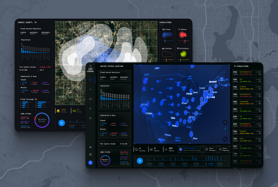
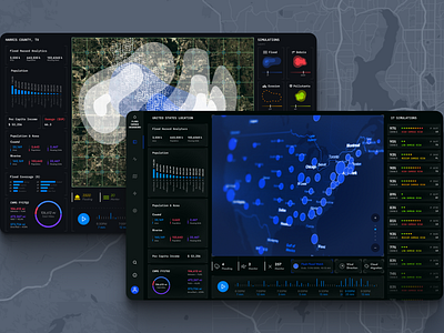
1. Impact of floods 3d bigdata dataanalitics datadashboard datascience datavisualization floods graphic design graphicdesign impacts of floods maps multilayermaps3 ui user interface ux web design
    View Impact of floods
    Impact of floods
    70
    7.8k
  2. 3D Landscape Elevation Map Backgrounds 3d 3d illustration 3d render abstract background c4d cinema 4d elevation elevation map generative generative graphic gradient hike illustration landscape mountains topo topographic travel wallpaper
    View 3D Landscape Elevation Map Backgrounds
    3D Landscape Elevation Map Backgrounds
    5
    2.4k
  3. Topographic map background black cartography contour design geography line map mountain navigation outline relief set terrain topo topographic topographic map topography vector white
    View Topographic map
    Topographic map
    1
    3.1k
  4. 90 Topographic Maps Vector contour contour line contour map line map map illustration mountain mountain map topograph topographic topographic map topographic map vector topography topography map vector vector map
    View 90 Topographic Maps Vector
    90 Topographic Maps Vector
    4
    2.3k
  5. Area Map Design - Mississippi River project arcgis basemap graphic design interactive keymap map mississippi river
    View Area Map Design - Mississippi River project
    Area Map Design - Mississippi River project
    1
    490
  6. Vector Topographic Map Kit background design header kit map resource topograph topographic topographic map
    3
    View Vector Topographic Map Kit
    Vector Topographic Map Kit
    29
    3.2k
  7. Map Infographic | TQMsoft countires design graphic design illustration infographic location map vector world
    View Map Infographic | TQMsoft
    Map Infographic | TQMsoft
    13
    7.6k
  8. Payaab compare comparison lake landing map sea map urumia urumia lake
    View Payaab
    Payaab
    14
    3.3k
  9. America's Wild Rivers Illustrations by Steven Noble artwork branding design engraving etching graphic design illustration line art map maps scratchboard steven noble ui woodcut
    View America's Wild Rivers Illustrations by Steven Noble
    America's Wild Rivers Illustrations by Steven Noble
    46
    7.6k
  10. Topographic Map Pattern (now for sale!) adventure camping contour elevation exploration lines map mountains outdoors topographic topography wayfinding
    View Topographic Map Pattern (now for sale!)
    Topographic Map Pattern (now for sale!)
    153
    59k
  11. Ceiling Map app design ceiling false ceiling home decor interface interior map product design redis startup typography ui ui kit user interface ux
    View Ceiling Map
    Ceiling Map
    111
    20.6k
  12. Illustration | Large Map Illustration 01 adobe illustrator beach brand agency brand studio colorful colors design flat illustration illustration illustration agency illustration design illustration studio island map map illustration maps vector illustration vector illustrations
    View Illustration | Large Map Illustration 01
    Illustration | Large Map Illustration 01
    91
    59.3k
  13. Copper Foil Topographic Rainier copper foil foiling map mountain mt paper print printmaking rainier topo topographic
    View Copper Foil Topographic Rainier
    Copper Foil Topographic Rainier
    45
    13.1k
  14. Alluvial - IBM Design Language Data Vis Animation
    View Alluvial - IBM Design Language Data Vis Animation
    Alluvial - IBM Design Language Data Vis Animation
    451
    24.4k
  15. World, meet the hand-drawn vector map patterns! 600 ppi bitmap tiff clarendon std design asset hand drawn map pattern png sbh the shop topography lines univers thin ultra condensed vector asset
    1
    View World, meet the hand-drawn vector map patterns!
    World, meet the hand-drawn vector map patterns!
    48
    8.8k
  16. Map Work castle design illustration infographic map river tree type
    1
    View Map Work
    Map Work
    88
    3.9k
  17. Wilderness Map forest map river stars trees wilderness woods
    View Wilderness Map
    Wilderness Map
    74
    2.7k
  18. Mount Fuji, Japan cartography colors custom map design fuji japan map mount fuji mountain sea terrain volcano
    View Mount Fuji, Japan
    Mount Fuji, Japan
    213
    15k
  19. Mapmaking illustration jungle lagoon land map rock topography water weathered
    View Mapmaking
    Mapmaking
    4
    856
  20. Topo branding idlewild map topographic
    3
    View Topo
    Topo
    138
    4.7k
  21. Kootenay River Floodplain Map cartography data visualization map mapping qgis
    View Kootenay River Floodplain Map
    Kootenay River Floodplain Map
    4
    826
  22. LAND OF RIVERS graphic design illustration map
    View LAND OF RIVERS
    LAND OF RIVERS
    0
    69
  23. Map flamingos map mountains river south africa trees
    View Map
    Map
    19
    1.3k
  24. Terrains collection 2: Mountain with waterfalls and river 3d art design fantasy gaea graphic design hills illustration landscape mountain mountains procedural terrain water waterfalls
    View Terrains collection 2: Mountain with waterfalls and river
    Terrains collection 2: Mountain with waterfalls and river
    0
    112
Loading more…