Mapping systems .3

Mapping Multi-Scalar Systems
with Harvard Graduate School of Design
Cambridge, 2019
team: O. Thurston, A. Schnurr, G. Micheletti
Analyzing social systems + mapping observations ethnogeographically within East Cambridge.
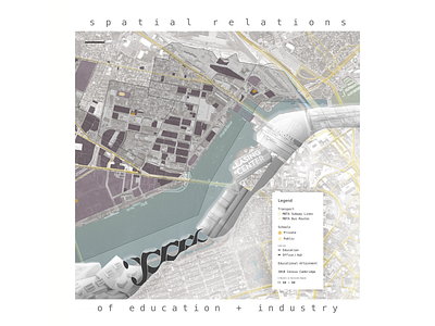
Education is a key lens through which to frame an understanding of the area’s greater context and projected development. In looking at spatial presence with curated land use maps, the high concentration of office, research + development, and higher education emerge as dominant forces. The area has high property values and low poverty rates. Given this, and by experimentation with researching these datasets, the decision to focus on the statistic of percent terminal degrees (i.e. master’s degree or higher) provided a key link in filling the gap in this picture.
Systems maps depict a high rate of terminal degree attainment, which had increased ~150% over 10 years, as well as residential land use deficit notably between both transportation hubs in Lechmere and Kendall Square.
Our conclusions encourage the opportunity for more accessible and community-oriented educational outreach. Residential development is needed to complement the presence and growth of MIT as a catalyst for the current state of the area’s various social systems.