Sydney Royal EasterShow - Custom Map 2021

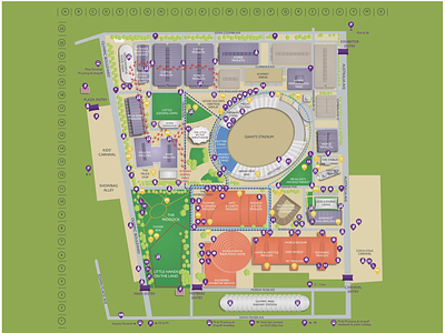

This is the Sydney Royal EasterShow Map. The map has been created as a vector format to suit multiple uses such as using for large format printing at the venue in signage, use on flyers and website. One of the main use cases is that this map contains high resolution latitude and longitude of POI's and uses our custom mapping software powered by Mobiconnect to provide users at the show wayfinding navigation at the show. The app uses this custom map to show how users can create an itinerary and the way-finding plots the best optimal walking route whilst at the show. The distance is showed in approximate steps, metres and approximate walking time.