Illustrated Map of South America

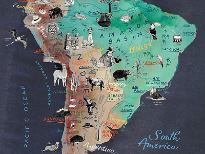


This is my new colorful hand drawn map of the South American continent. It shows all major countries like Brazil, Argentina, Chile, Peru, Uruguay, Paraguay, Bolivia, Colombia, Venezuela, Guyana, Suriname and French Guiana and their capitals. The map focuses on the stunning wildlife and nature of South America as well as on touristic highlights, the highest mountains and the Panamericana route.
I have used a combination of a colorful painted background together with hand lettered place names and pencil illustrations of the highlights.
To get the full view the map is also available in my online shop as a high quality art print: https://www.etsy.com/listing/739580124/south-america-map-art-print-illustrated